
Intense waves and floods batter California waterfront homes and boardwalks
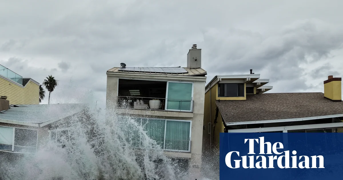
Southern California coastal communities are picking up the pieces after a weekend of extreme weather brought flooding that overtook city streets and intense waves battered beachside homes.
The remnants of Tropical Storm Rachel hit Mexico’s Baja California over the weekend as well as southern California and Las Vegas. While meteorologists noted that Rachel weakened into a post-tropical cyclone as it approached California, it still left a trail of destruction.
Footage showed massive waves crashing into Long Beach homes, destroying a boardwalk and forcing residents to flee. The damage to homes was significant, leaving some at risk of collapse.
At least nine have been deemed unsafe to enter, the Long Beach Post reported, meaning displaced residents cannot return to retrieve personal items. The storm has cost the city more than $1m from its emergency reserves, according to the outlet.
Farther south, the city of Newport Beach declared a local emergency and briefly closed piers to “protect public safety”, citing “higher-than-normal surf” that inundated streets.
By Monday, cleanup work was under way and Newport Beach had reopened the piers, but officials advised residents to exercise caution near the water.
In Las Vegas, a raging torrent of water rushed over a street near the strip, and the city tied an all-time daily rainfall record for October with 1.08in (2.74cm) of rain into Sunday morning, according to the US National Weather Service.
The impacts are just a taste of what’s to come across southern California as a historic El Niño unfolds in the Pacific, threatening to unleash severe storms across the region this winter.
Already, the last five hurricanes in the Pacific all reached major status and saw with winds of at least 111mph (178.6 km/h), and one set a record for time spent at category 5.
“This year, just everything that forms is just lasting a long time and getting really powerful,” Phil Klotzbach, a Colorado State University researcher who forecasts and studies storm activity, told the Associated Press, adding that the last month has been “berserk”.
The El Niño climate phenomenon, characterized by warmer than average equatorial sea surface temperatures, has the potential to supercharge extreme weather around the world. While it’s expected to strengthen through the end of this year and into next, the excess warmth already measured is climbing off the charts. Forecasters have warned its effects could become exceptionally destructive.
In California – especially in the southern part of the state – El Niños typically carry higher risks of severe storms, and with them elevated threats from landslides, debris flows and flash floods. These dangers become more pronounced around recent burn scars, adding hazards to several areas, including in the neighborhoods still recovering from the 2025 Los Angeles firestorm and swaths of Big Sur above Highway 1.
“This year’s tilt in the odds toward wet and stormy conditions in California will be profoundly unsubtle,” climate scientist Daniel Swain said in a recent analysis, adding that its unlike anything he’s observed before.
Throughout the winter months, El Niño could also add an additional foot of sea level rise in California on top of the 8in to 12in caused by the climate crisis over the last century, according to Michael Anderson, a state climatologist.
Already, El Niño has elevated sea levels up and down the California coast, from the Mexico border up to the San Francisco Bay Area. Warm waters expanding from an extreme marine heatwave combined with a coastally trapped Kelvin wave – a large underwater band of warm water – have already inundated parts of the North American shoreline. More Kelvin waves are likely and California is already bracing for unusually high king tides to hit during holiday weekends this year, arriving near Thanksgiving and Christmas.
While the impacts from heavy rains and high surf are each destructive in their own right, when they align and overlap they can cause even more calamity.
“Between November 2026 and January 2027, I would anticipate multiple significant coastal flood events that are worse in severity and also much more widespread than what we are currently seeing,” Swain said. “Even a moderate storm could bring water levels higher still, and a strong storm would likely produce widespread damaging, and probably historic, coastal flooding.”
Meanwhile, as cities across California begin preparations for intense winter weather, there are still months left before the risks from fire begin to subside. The National Weather Service issued fire weather watches for parts of southern California, including in Los Angeles, as seasonal strong, dry winds align with high temperatures. Forecasters warned that there would be “high risk for extreme fire behavior with any new fire starts Thursday through Friday”.
With the threat of fire, heat and sea level rise colliding, as the state readies for more incoming effects from El Niño, Kevin McGowan, the director of LA’s office of emergency management, urged residents to be ready. “People should continue to prepare not just for one hazard,” he said during a recent briefing, – but all hazards.”
The Associated Press contributed reporting
Related Stories
 World
World
Allies did not warn Kyiv of Russian ballistic missile strikes, says Zelenskyy
46 minutes ago
 World
World
Christian leaders unite in prayer for Pope Leo XIV
1 hour ago
 World
World
In first visit to Ceuta, Spain's king asks for 'good faith' from Morocco after migration crisis
1 hour ago
 World
World
Battle lines shift in House races as Republicans retreat from front
1 hour ago
 World
World
Is there anything like October for sports in LA? Local businesses ride the hype of World Series excitement
2 hours ago
 World
World
Pictured: Winning entries for Wildlife Photographer of the Year 2026
2 hours ago
 World
World
Haze: Who's to blame for the toxic smog choking South East Asia?
2 hours ago
 World
World
COLUMN | Trump Is Going to Lose the Midterms.
2 hours ago