
Radar Tech Revives Flood Monitoring in Cairns
Far North Queensland communities benefit from better flood forecasting
Communities across Far North Queensland now have better flood forecasting after the bureau's Flood Warning Infrastructure Network (FWIN) Program restored a key water level gauge at Cairns Airport.
Severe flooding during Tropical Cyclone Jasper damaged the station in December 2023. The site could no longer provide reliable data needed for flood forecasting on the Barron River.
Repairing the Cairns Airport gauge was a high priority due to its importance for forecasting and community safety. The project also gave the FWIN Program an opportunity to trial a new type of technology.
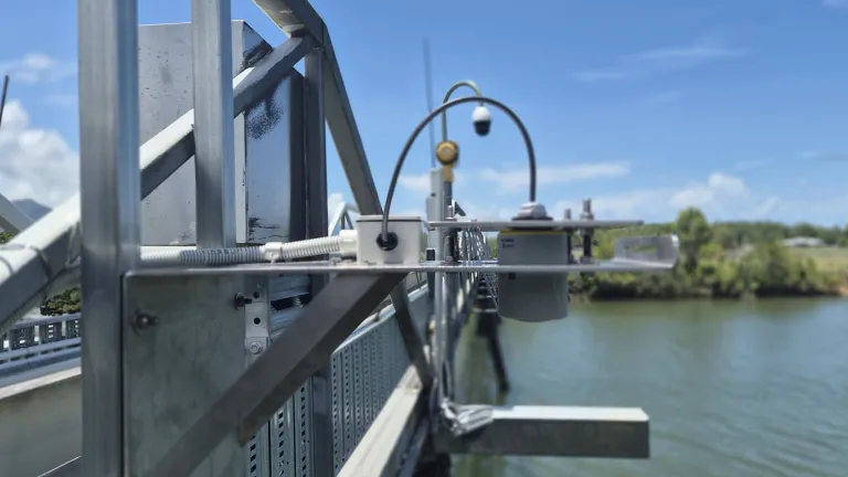
In December 2025, the FWIN Program installed its first water level radar at the site. The new equipment restored the station and brought detailed flood forecasting for the Barron River back into service.
The station is now sending real-time water level data to the Bureau. This helps forecasters provide more accurate and timely flood information during severe weather.
The Cairns Airport gauge, located on the Barron River, provides data that helps forecasters issue accurate flood warnings
Turning a challenge into an opportunity
The damage caused by Cyclone Jasper created a unique challenge. Rather than replacing the site with the same equipment, the FWIN Program saw an opportunity to trial a more innovative approach using new radar technology.
Most water level gauges have sensors that sit in or near the water. Flood events can damage this equipment. Sediment build-up and changing river conditions can also affect its performance over time.
The new radar system measures water levels remotely from above the river surface. This approach offers several benefits:
In a region regularly exposed to severe weather, resilient and more adaptable monitoring technology helps ensure critical information remains available when communities need it most.
Following the success of this installation, the FWIN Program has identified 9 additional sites where the technology will be implemented, expanding the benefits of improved flood monitoring and enhanced field safety across the network.
The FWIN Program installed the first water level radar at Cairns Airport, helping restore vital flood monitoring and forecasting services for the region
With the Cairns Airport gauge back in service, forecasters can once again use real-time water level data to support flood forecasts and warnings for the Barron River. This provides locals and visitors with more accurate and timely information during flood events.
Reliable flood data is an important part of Australia's flood warning network. It helps emergency services, councils and local communities understand changing conditions and prepare for severe weather.
The success of this project shows how the FWIN Program, coupled with bureau hub teams, is helping strengthen flood warning services across Australia through modern technology and practical solutions.
Related Stories
 Technology
Ukraine war: Russian glide bomb attack on Zaporizhzhia kills at least 15 people
2 minutes ago
 Technology
Bull of the Day: GigaCloud Technology Group Inc. (GCT)
2 hours ago
 Technology
Gaming, AI, tech parks power Türkiye's startup ecosystem
6 hours ago
 Technology
AI, Tech Leaders Are Lobbying Trump Health Officials in a Government
6 hours ago
 Technology
Trump says he picked ‘devoted fan’ Katie Zacharia to be next press secretary
8 hours ago
 Technology
Weather Updates for Saturday’s Georgia Tech
8 hours ago
 Technology
Questor Technology Inc. (QST.V) Stock Price, News, Quote & History
11 hours ago
 Technology
Ruanyun Edai Technology receives Nasdaq minimum bid price notice
14 hours ago