
Severe thunderstorm possible for N.B. on Tuesday
Severe thunderstorm possible for N.B. on Tuesday
Thunderstorm watch comes with risk of large hail, damaging winds, heavy rain and tornado
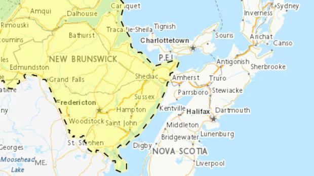
Severe thunderstorms that could be accompanied by large hail, damaging winds, heavy rain or even a tornado are possible for New Brunswick on Tuesday.
Environment Canada issued severe thunderstorm watch alerts for Tuesday afternoon and evening.
Watches are issued when conditions are favourable for severe thunderstorms, but a warning would be issued issued if one were developing, said Jill Maepea, a New Brunswick-based meteorologist with Environment Canada.
"It doesn't mean every area of the province is going to see a warning," she said. "We're going to be tracking these individual severe cells, and then warnings will probably be issued as necessary this afternoon."
Maepea said there appears to be a slightly higher probability of severe weather happening in the northwest of the province, but a development in that area could then drift into other parts of the province.
Maepea said a lot of factors go into determining how severe thunderstorms form. She said Environment Canada tries to predict them, but severe thunderstorms can develop extremely rapidly.
"It's not something we can track like a large winter storm," she said. "It's not like we're tracking this thunderstorm that's, you know, in Quebec and it's going to come all the way across. These develop very rapidly and sometimes they also dissipate very rapidly.
"It's very hard to predict and also track."
Tornado risk low, meteorologist says
Maepea said the risk of a tornado is low. Tornado risk is often associated with severe thunderstorm formation, but she said the larger threat for Tuesday is likely the strong winds, as opposed to a tornado.
Maepea said if a warning is issued for a particular region, people in that area should secure their belongings, cover their vehicles if possible and go inside to a safe place.
According to Environment Canada's Atlantic thunderstorm outlook, the western and northwestern areas of the province have a high weather risk for winds of 90 to 110 kilometres an hour, hail one to three centimetres in diameter, and 30 to 60 millimetres of rain.
The rest of the province has a moderate risk, according to the outlook, of 90 to 100 km/h winds, one to two-centimetre hail and 30 to 60 millimetres of rain.
Hannah Rudderham is a reporter with CBC New Brunswick. She grew up in Cape Breton, N.S., and moved to Fredericton in 2018. You can send story tips to hannah.rudderham@cbc.ca.
Related Stories
 Canada
Health Canada suspends collection at Manitoba donation site
40 minutes ago
 Canada
N.W.T. officially ending seasonal time changes
40 minutes ago
 Canada
2 people killed, 1 person arrested following Highway 1 crash in Burnaby
40 minutes ago
 Canada
Israeli bulldozers smash Palestinian olive trees ahead of annual harvest
1 hour ago
 Canada
Trump claims Canada’s ‘Liberal takeover’ will ‘end very badly’
1 hour ago
 Canada
Metro Vancouver gets warrant to seize Parkland refinery documents following 2024 chemical leak | CBC News
1 hour ago
 Canada
As Alberta separatism referendum looms, flags become symbol of voting intention
1 hour ago
 Canada
New federal funds support pandemic preparedness research
1 hour ago